Basic principle overview
The GPS satellite ephemeris is based on the WGS-84 geodetic coordinate system, so the coordinate system used by the handheld GPS is the WGS-84 coordinate system. At present, the coordinate systems used by hand-held GPS on the market are basically WGS-84 coordinate systems, and most of the map resources we use belong to the 1954 Beijing Coordinate System or the 1980 Xi'an National Geodetic Coordinate System. Different coordinate systems have brought difficulties to our use. Therefore, there has been a problem of how to convert the WGS-84 coordinates to the 1954 Beijing coordinate system or the 1980 Xi'an National Earth Coordinate System. As we all know, there is a relationship between translation and rotation in different coordinate systems. To convert the data measured by hand-held GPS into its own required coordinates, two coordinate systems must be calculated (WGS-84 and Beijing 54 coordinate system or Xi'an 80). Conversion parameters between coordinate systems). Therefore, if you want to obtain the last WGS-84 coordinate system data, you must perform coordinate conversion and input the corresponding coordinate conversion parameters. As long as the user calculates five conversion parameters (DX, DY, DZ, DA, DF) and enter the GPS as prompted, the coordinate transformation can be performed automatically on the GPS instrument to obtain the corresponding Beijing 54 coordinate system (or Xi'an The coordinates of the 80 coordinate system).
The following takes the Beijing 54 coordinate system as an example to find a method for coordinate conversion of handheld GPS receivers.
one. Collect high-level control point data in the application area
Find three (or more) evenly-distributed points in the area where you are using a handheld GPS receiver to fetch soil (such as a county) (the higher the accuracy is, the better) or the GPS "B" level network point. The best position is There is no electromagnetic interference around and the horizon is wide and the satellite signal is strong. Go to the local surveying and mapping management department (eg local surveying and mapping bureau, surveying and mapping institute) to copy the Gaussian plane rectangular coordinates (x, y), height h, and the geodetic latitude and longitude of the WGS-84 coordinate system of the Beijing 54 coordinate system (B, L), Earth high.
two. Find coordinate conversion parameters
The coordinate data of the above-mentioned control points are provided to the relevant person in charge of the branch offices of the technical support unit Beijing Hezhong Zhuang Zhuang Corporation to solve the coordinate conversion parameters, or obtain the conversion software for conversion. After the conversion parameters are found, press the prompt to enter the handheld GPS. Just after such a setting, all the coordinates read by GPS at the time of soil measurement in this area will be the Beijing 54 coordinates of the point.
three. Parametric test
After the five conversion parameters of DX, DY, DZ, DA, and DF are obtained, they must be input into the handheld GPS according to the prompts, and the center meridian longitude of the measurement area must be input at the same time. E stands for the longitude, the projection ratio parameter is 1, the east-west deviation is 500000, the north-south deviation is 0, and the unit is the meter. After entering these parameters, field inspections should be performed to verify that these five parameters are correct. The method is to select the feature points (such as line-shaped object intersections, independent features, etc.) with wide field of vision and strong GPS signals in the field. It is best to measure the buried stone control points and then find the theoretical coordinates of these points. Compared with it. If the comparison result exceeds the nominal accuracy of the instrument, the conversion parameters should be recalculated or the problem should be found.
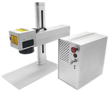
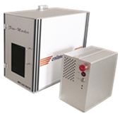
CNI released the Mini Laser Marking Machine - intended to provide customers convenient, fast, efficient and economical marking solutions. According to different Laser source, this machine can be divided into two type, 1064nm and 532nm Laser Marking Machine. Its compact design and high-quality marking performance has gradually become the mainstream of the market.
 |
 |
|
OEM Laser Marking machine |
Laser marking machine with protective housing |
|
|
|
| Features | Applicable marking materials |
| • Best price / performance ratio in the laser marking world | • Metal (gold, silver, copper, Iron, aluminum, titanium, zinc, steel...) |
| • Easy assembly, simple structure | • Plastic (PC, PVC, PE, HDPE, ABS, PPR, PET, HIPS, PS, PP, |
| • Small volume, portable and mobile | PPO.PA.POM.PMMA...) |
| • Air cooled with ultra-compact design | • Glass, leather, mobile phone charger... |
|
|
• Eggs, apples, vegetables.
|
Laser Marking Machine
End-pumped Laser Marking System,Laser Marking System,Green Laser Marking Machine System,Fiber Laser Marking Machine
Changchun New Industries Optoelectronics Technology Co., Ltd. , https://www.lasersciences.com